
A harbor over which a drone is flying.

Multi-layered counter-UAS for critical infrastructure operators

Contact us

Why CUAS is a critical infrastructure continuity and safety requirement

Low cost uncrewed aerial systems (UAS) have turned low altitude airspace into a persistent operational concern. For critical infrastructure (CI) operators, the challenge is executing the Detect – Decide – Respond workflow in a way that protects continuity and safety while withstanding legal constraints and external scrutiny.

Critical infrastructure environments are defined by high consequences with little tolerance for uncontrolled air activity. Decisions must be defensible to regulators, auditors and stakeholders, while response options may be legally or operationally constrained. Drones can be used for surveillance, disruption and targeting, and continue to proliferate and evolve. In critical infrastructure settings, incidents can disrupt operations and create cascading effects, making early warning and structured escalation essential to protect people, assets and operations across sites.

Operational realities:

  • High value sites with strict security perimeters
  • Multi site exposure with cascading impact potential
  • Authority constraints requiring escalation to public authorities
  • Auditable documentation requirements

THORIS - Our solution for countering drones over critical infrastructure

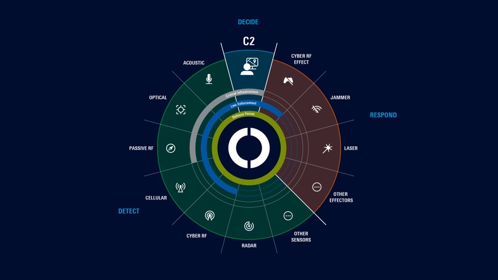
THORIS is a multi-layered counter-UAS system with modular architecture, one unified operational air picture, and a design that is sensor, effector and platform-agnostic. It provides a unified Detect – Decide – Respond chain and supports governed workflows and auditability for critical infrastructure operations.

Closing the counter-UAS capability gap for critical infrastructure

Many organizations can detect drone activity yet cannot consistently decide and respond fast enough – lawfully, proportionately and with accountable oversight – especially in complex airspace and congested spectrum environments. In practice, the bottleneck is rarely a single sensor, but rather the end-to-end chain of actions, starting with fusion into a coherent picture, clear authority, rehearsed workflows and, finally, a coordinated response in line with legal constraints. This is why a practical operating model is built around the Detect – Decide – Respond workflow.

How to close the CUAS gap:

Persistent layered situation data

Use persistent, layered situation data to reduce blind spots and ambiguity early and speed confirmation in congested environments.

Open Lightbox

Defensible decision making

Build defensible decisions with governance aligned workflows and audit ready logging that stands up to regulators, auditors, and stakeholders.

Open Lightbox

Proportionate response toolbox

Apply a proportionate toolbox to support risk-based handling within legal constraints and deconfliction requirements while avoiding unnecessary disruption.

Open Lightbox

Integration into operations

Integrate into existing infrastructure and workflows to reduce latency across stakeholders and enable structured escalation to public authorities.

Open Lightbox

Why multi-layered counter-UAS matters in CI environments

No single sensor or method can address every drone scenario. Drones differ in size, speed, flight profile, emission behavior and autonomy. A multi-layered approach combines complementary technologies and fuses them through command and control to enable confident decisions, coordinated responses and an auditable incident narrative.

Layered situation data that reduces blind spots:

  • Passive RF is powerful when drones emit RF signals and can provide early warning via RF direction finding and other RF-based identifiers (where available)
  • EO/IR provides confirmation and identification that reduces false alarms and supports evidence, yet it is limited by weather and typically needs cueing to cover a large area with a small number of cameras.
  • Radar for wide-area detection and tracking, even when RF cues are limited or absent
  • Acoustic is passive gap filler at short range; limited range and noise sensitivity
  • Unified C2 fuses sensor data into an integrated air picture and supports the Detect – Decide – Respond workflow with decision support, prioritization and proportional countermeasure recommendation; embeds governance and auditability

Key principle: Reduce uncertainty early enough to avoid binary outcomes (e.g., shutdowns) – fuse layers into one operational picture; quickly confirm and classify and use audit-ready evidence as the basis for a clear escalation workflow.

What is allowed?

What is allowed: response constraints, escalation and defensible action in critical infrastructure

The challenge is not just detecting drones but identifying the intent of their pilots and responding appropriately – and legally – in a crowded electromagnetic spectrum.

In domestic and safety-constrained environments – including critical infrastructure contexts – response options are typically limited by legal guidelines, deconfliction requirements and collateral risk. These constraints tend to favor non-kinetic measures and tightly controlled escalation. In line with compliance expectations (Umbrella Act for Critical Infrastructure Protection), operators must be able to prove timely detection, escalation and documentation. This makes auditable logging and evidence-ready workflows core requirements.

Critical infrastructure-specific authority:

  • CI operators often have no direct response authority on site and depend on escalation to public authorities.
  • This lack of their own response authority means that counter-UAS must support clear escalation workflows and evidence capture from the first alert to the incident review.

Designed for critical infrastructure

Critical environments require persistent awareness, disciplined classification (authorized vs. unknown vs. threat) and clear escalation workflows across stakeholders plus evidence capture for compliance, liability management and continuity justification. Different enviroments like Airport, power plants, data centers or ports require specific solutions.

Airport drone security

Detect unauthorized drones, assess risk and safeguard operational safety.

More information

Public event drone defense

Control event airspace and stop unauthorized drones.

More information

Drone defense for energy providers

Keep critical energy infrastructure running.

THORIS: your benefits in a nutshell

  • Continuous visibility for high-safety operations: Persistent awareness for early risk recognition in low-altitude, cluttered environments.
  • Measurement-grade data for regulators, auditors and stakeholders: Calibrated, time-synchronized data delivers trusted, reproducible evidence.
  • Rapid localization and disciplined classification: Faster confirmation for clear classification and escalation.
  • Operational continuity through coordinated incident workflows: Integrated situational awareness and workflow support reduce coordination latency between teams and sites
  • Audit-ready evidence as an operational capability: Verifiable records with clear provenance for compliance and review.
  • Governance-aligned operations under response constraints: Governance-aligned workflows that support consistent decisions under constraints.
  • Turnkey delivery for complex CI environments: End-to-end delivery and lifecycle support to reduce operational burden.
  • Sector-tailored expertise across verticals: Application knowledge across CI use cases translates technology into reliable performance.

Ready to strengthen your CUAS capability? Talk to Rohde & Schwarz experts about layered detection, multisensor awareness, integration into existing architectures and controlled response.

FAQs - counter-drone protection for critical infrastructuredrones

Stay connected and informed

Sign up for our newsletter and join us on LinkedIn

Request information

Do you have questions or need additional information? Simply fill out this form and we will get right back to you.
For service/support requests, please go here to log in or register.

Marketing permission

Your request has been sent successfully. We will contact you shortly.
An error is occurred, please try it again later.