Mobile network testing blog

Stories & insights

Mobile network testing

Written by Pak Lun Lam | October 17, 2019

Network measurements with drones: The next step to a connected sky

In the era of Internet of Things (IoT), one of the most urgently discussed topics concerns the deployment of Unmanned Aerial Vehicles (UAVs) to automate different commercial applications, ranging from simple mail delivery to offshore islands to more sophisticated aerial taxis. This blog post shows the results of mobile network measurements conducted with drones, which serve as the basis for further evaluation of potential UAV applications.

Network Measurement with drones

In Singapore, the Ministry of Transport is working with multiple government agencies to assess the use of UAVs for commercial applications on land as well as in the southern seaport. Dedicated “drone estates”, such as the “maritime drone estate”, have been designated to offer companies and research institutions different environments to test and develop drone technology for different applications1.

Singapore can very well imagine a future in which UAVs are roaming the skies and executing these newly developed commercial applications. So, how does a country effectively deploy UAVs in densely populated urban environments?

In order to have a coordinated approach and to ensure safety guidelines, Unmanned Traffic Management (UTM) systems are being developed to connect and operate multiple drones simultaneously. UTMs will thus require a reliable, wide-area backhaul communication network. With LTE being a proven and readily available technology2, many UTM companies choose this cellular technology as one of the networks for UTM deployment.

This makes us wonder whether the existing communication networks (i.e., LTE networks) cater sufficiently for these new drone use cases. Most LTE networks are designed for use at street level, so what is LTE network coverage at the flight altitudes of UAVs like? Network latency is another important consideration as every millisecond delay in communicating with the UAVs might cause a mid-air collision between UAVs. And, will there be sufficient data throughput for specific UAV applications such as video surveillance?

Measurement solutions mounted on a drone

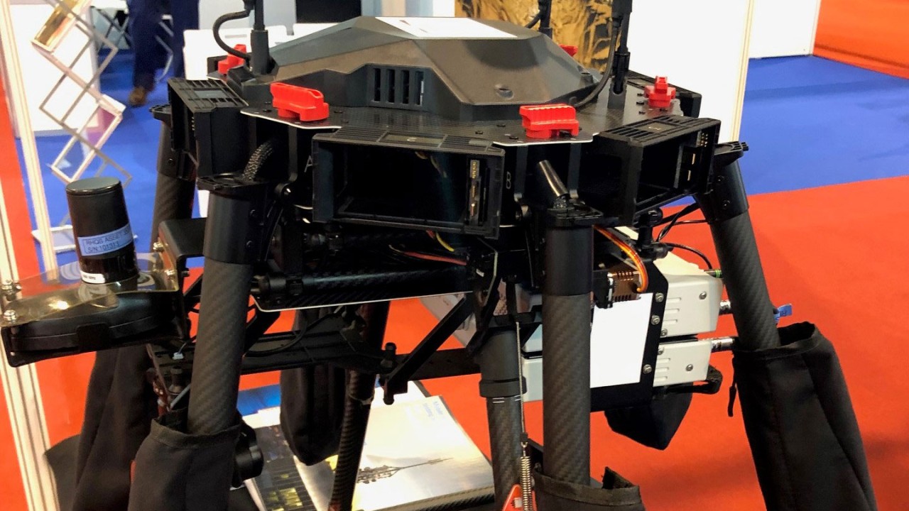
Rohde & Schwarz mobile network testing (R&S MNT) is a leading provider of drive test tools, including RF scanners and specialized handsets (smartphones) for testing network quality of service (QoS) and quality of experience (QoE). With their small and compact form factor, the R&S scanners and QualiPoc Android handsets are easily mounted on UAVs that are used for flight tests over designated “drone estates” to test the network quality at flight altitudes.

A drone equipped with two R&S®TSMA6 scanners and two QualiPoc Android smartphones

By testing the QoS and QoE of LTE networks at flight altitude, we can identify problem areas in the UAVs’ path and altitude such as insufficient network coverage, a lack of data throughput, or high latency, which can be problematic for the UTM communicating with the UAVs. Rohde & Schwarz has partnered with UTM vendors for flight trials in different parts of the world to collect valuable information regarding LTE network characteristics in the varying heights of the UAV flight paths.

Coverage at different flight altitudes

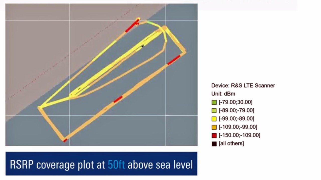
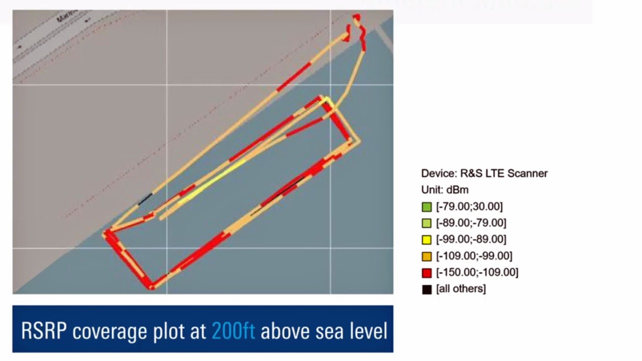
In a recent trial, conducted with R&S®TSMA6 RF scanners and QualiPoc Android handsets mounted on a UAV, we determined the coverage of a UAV’s flight path at different altitudes by measuring and plotting network coverage parameters such as Reference Signal Received Power (RSRP) and Signal-to-Interference-plus-Noise Ratio (SINR). At the same time, we used the mounted QualiPoc Android handsets to conduct latency and data throughput tests to identify potential problem areas at different altitudes.

RSRP coverage plot at 50 feet above sea level (left) versus at 200 feet above sea level (right)
Open Lightbox
RSRP coverage plot at 200 feet above sea level (right)
RSRP coverage plot at 50 feet above sea level (left) versus at 200 feet above sea level (right)
Open Lightbox

From the map plots above, we see that the LTE network coverage at an altitude of 50 feet is much better than at 200 feet. At 200 feet above sea level, the current network coverage would not be sufficient for the deployment of UTM systems, as communication with the UAVs cannot be guaranteed. The diminishing network coverage is probably due to the downtilt of the LTE base station antennas aiming to cover street levels instead of flight altitudes.

Operators to improve coverage and latency

LTE coverage measurements with R&S®TSMA6 RF scanners, and data throughput and latency measurements with QualiPoc Android handsets provide telecom authorities and operators with a valuable overview of current LTE capabilities.

Given our trial, the mobile network operator will need to improve network coverage and resolve any latency or data throughput issues at flight altitude so that UTMs can have complete control of the deployed UAVs in this particular “drone estate”. Looking ahead, 5G will help to improve the UTM’s needs further, in particular, the latency KPI by using special means for URLLC (ultra-reliable low-latency communications) use cases.

As discussed earlier, it is vital to ensure that the quality of the UTM’s communication network is reliable in order to have seamless control of the UAVs in the designated areas. Thus, it is critical to test the network quality at the high altitudes in which UAVs fly before any UTM can be successfully deployed. R&S MNT has the expertise, experience, and tools to support this important network testing phase as we are partnering with UTM companies to move into the era of IoT.

Find more information about our network measurement solutions mounted on drones in the video below:

Staging well connected skt with R&S mobile network testing solutions

References:
1 Maritime drone testing area to be set up near Marina South Pier, The Straits Times, March 7, 2019
2 A Telecom Perspective on the Internet of Drones: From LTE-Advanced to 5G, China Mobile Research Institute

Related stories

Interactivity test: QoS/QoE measurements in 5G (part 1)

Read more

Machine learning: Time-based anomaly detection (part 3)

Read more

Interactivity test: Concept and KPIs (part 2)

Read more

Subscribe MNT blog

Sign up for our newsletter

Stay up to date and get stories and insights with our frequent mobile network testing newsletter.

Stories by category

Benchmarking & optimization

More information

Field services & interference hunting

More information

Innovations in mobile network testing

More information

Testing from RF to QoE

More information

Request information

Do you have questions or need additional information? Simply fill out this form and we will get right back to you.

Marketing permission

Your request has been sent successfully. We will contact you shortly.
An error is occurred, please try it again later.